
The railroad boom is a story about investors and investments. To explain the mania I decided to take a side track (another railroad term!) to explore what railroads meant to the places they passed through. I live in Bloomington/Normal Illinois, a place that was strongly influenced by the railroads that ran through it. I thought some history of my place might help illuminate the impact the railroads made.
The transportation system of 1835: rivers
Illinois used to be “the West”. For a long time it was about as far west as you could go. The entire western border of Illinois consisted of the wide banks of the Mississippi River. Before the construction of bridges and railroads, it was pretty hard to go any further west than that. Later we started calling it the Midwest, when it became more populated and there were other places to go even further west.
The story of railroad expansion into Illinois began around 1835. Before that there were no railroads anywhere in the state. If you wanted to migrate to Illinois from somewhere in the East, there was only one obvious route. You got on a riverboat and rode the Ohio River downstream to where it joins the Mississippi, which is the very southern tip of Illinois. At that point you could go further south on the Mississippi, or jump off the boat. So all the early settlements in Illinois were located in the south, along the river.
Before the era of the steamboat, going upstream was difficult or impossible. But the steamboat changed that, making the western side of Illinois accessible from boats running up and down the Mississippi River. So the next part of Illinois that was populated was the western part of the state, along the Mississippi. All the early important towns in Illinois were next to rivers, generally the Ohio and Mississippi, but also some of the interior rivers, like the Illinois River and the Wabash River.
Chicago, back then, was not a huge city. It was by a waterway, the tip of Lake Michigan. But the Great Lakes were disconnected from the East. In 1825, the Erie Canal connected the Great Lakes to the Hudson River, which finally created a route from Chicago to the Atlantic Ocean, and all the commerce centers in the East.
Another big canal would change Chicago’s fortunes. Construction on the Illinois and Michigan Canal started in 1836 and it was finished in 1848. The canal connected Lake Michigan to the Illinois River, which gave Chicago access to the west, to the Mississippi River and ultimately the Port of New Orleans.
There were no railroads into Chicago from the East back then. Not until 1852 could you ride into Chicago on a railroad from the East. That’s when the Michigan Southern Railroad reached the city.
In 1835 Illinois was a huge state geographically, but the population was concentrated in a few areas along the rivers at its edges. In 1835 it was not at all obvious that Chicago would be an important city, because it wasn’t yet well-connected. The center of Illinois was sparsely populated, and almost all of the interior population at the time was located on one of the inland rivers. Roads were few and poorly maintained. They flooded and were full of ruts. You could sink into the mud halfway up your wheels after a rain. Travel by road was slow and difficult. The only easy way to travel was by water.
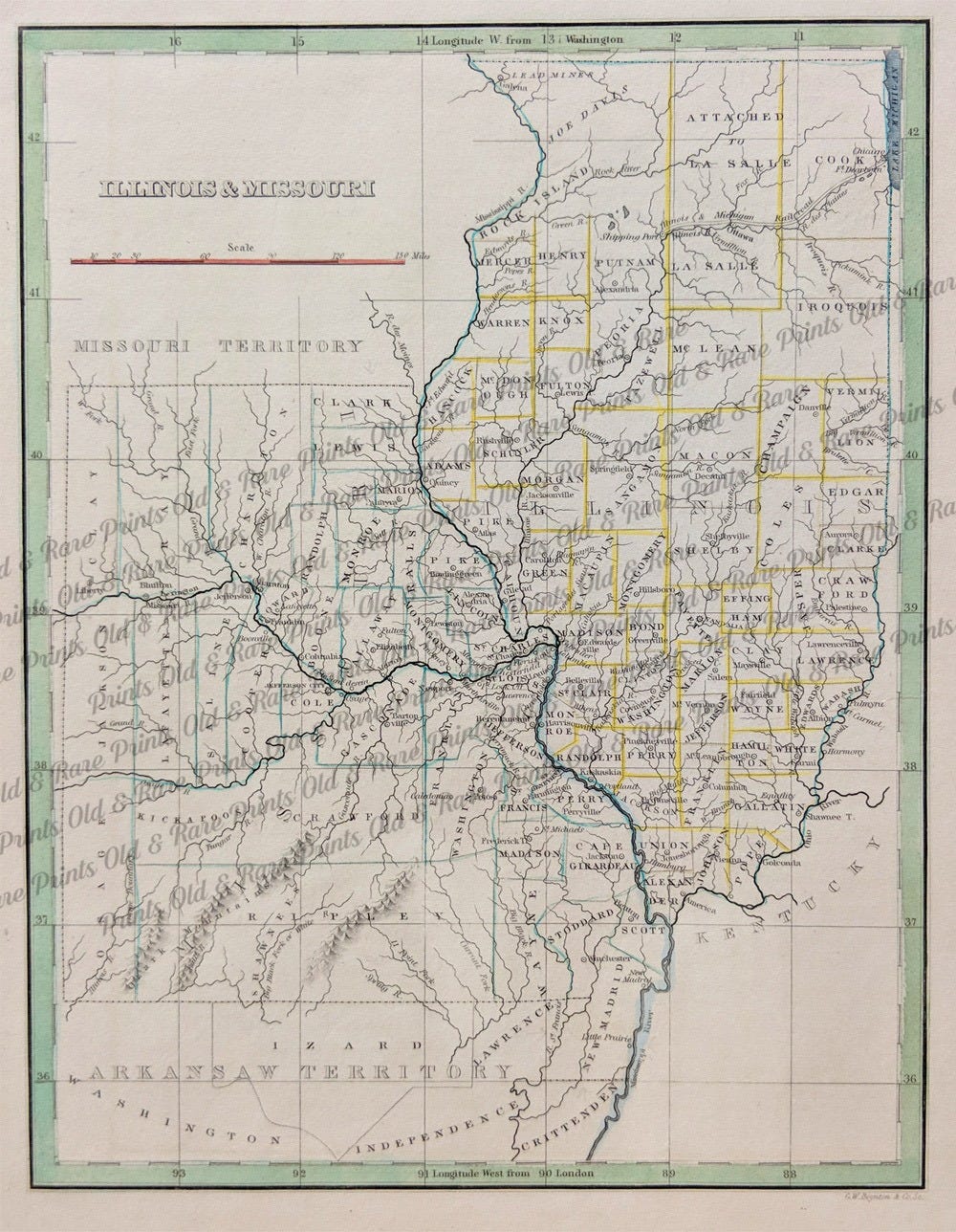
Here is a map from 1835. Every place that is important enough to have a name is by a river. Many big cities of today are completely missing. And almost all the places that have names are in the southern part of the state.
In 1835, the railroad boom was taking off in other places. Powerful people in Illinois started conversations about how to get a railroad built in Illinois. Stephen Douglas claimed that he was the one who originally proposed the idea of a central Illinois railroad in 1835. Others disputed whose idea it was. Either way, the idea that was forming was to create a railroad that would go all the way north to south, cutting through the heart of the state.
This is where I stop and talk about paradigms. A paradigm is a widely understood way of understanding the world. In 1835, the paradigm was that water navigation would always be the thing that really mattered. All the early discussions about railroads were about creating ways to connect waterways together. Nobody really was thinking yet about railroads as a whole new method of transportation!
So the early discussion about the railroad in Illinois was how to connect rivers in the north, like the upper Mississippi, with the rivers from the east, like the Ohio, and the Great Lakes, and the Illinois and Michigan Canal. The first plan for the first railroad in Illinois was to create one terminus in Galena, Illinois, at the very northwestern tip of Illinois, and another at the junction of the Ohio and Mississippi Rivers at the very southernmost tip of Illinois.
Where will the railroad go, and how to pay for it?
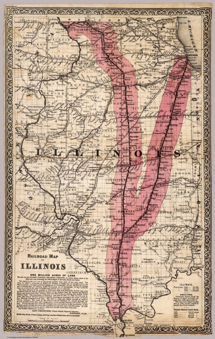
At the time, Galena was an important lead mining area and port. And it could eventually be the connection to places further west. There was actually no existing city in the south at the junction of the Ohio and Mississippi River, so the Illinois legislature created one, to be called Cairo. The railroad route would go southeast from Galena to Ottawa, where the Illinois and Michigan Canal would eventually meet the Illinois River, then drop south to Cairo. That would be the main line.
There was a lot of discussion about whether or not to add a railroad branch running to Chicago. The compromise that won was to create a system that looked like a big “Y”, with Cairo in the south, running north, and then branching off in two directions, one to Galena and one to Chicago. The main line ran between Galena and Cairo, the line to Chicago was the branch line, the secondary line.
There were several attempts to get this project going. The legislature debated and discussed many plans, and actually enacted a couple of them. They created a series of railroad companies that couldn’t raise funds or that went bankrupt.
In March of 1837, the Cairo City & Canal Company was incorporated. That bill created the city of Cairo at the junction of the Ohio and Mississippi Rivers and a company that was to build and improve canals in the area. Again, note that the focus was still on waterways, not railroads.
In March 1843, the state legislated The Great Western Railway Company into existence. That company was owned and run by the president and directors of the Cairo City & Canal Company. It was supposed to build a railroad from the mouth of the Ohio River to the junction of the Illinois and Michigan Canal and Illinois River. The company quickly went bankrupt, and its charter was revoked in 1845.
There were several more attempts to create a railroad for Illinois, but everything continued to fall apart with little or any success. There were disputes about whether or not the railroad should go to Chicago, how it should be paid for, whether or not the state should grant it land, and many other things.
Illinois didn’t have enough land to create a railroad route, but the US government did. In 1849 congress approved a plan to allow any state that contained public lands to use those lands to build railroads and canals. That answered the question about where the land would come from, but also meant that anything that was done under that act had to be acceptable not only to people in Illinois, but also to people in other states, so they could get the congressional votes they needed.
Eventually a plan came together. The name of the railroad would be the Illinois Central Railroad. It would run from Cairo to both Galena and Chicago. The railroad would eventually extend beyond Illinois, south to Mobile, Alabama and west to Iowa, making it beneficial to other parts of the country.
The land grants
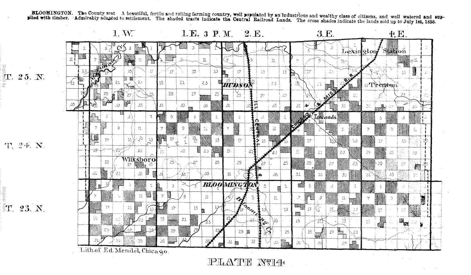
The railroad would acquire land via land grants. The land granted would be divided. Half of the land, every other section, would be given to the railroad company. The remaining sections would be retained by the government. The expectation was that the construction of the railroad would greatly increase the value of the land, and the government would be rewarded by the increased land value for their gift. The federal government would grant land to the state and the state would then grant it to the railroad.
This was the first use of land grants to build a railroad in the United States. Land grants were later used to build the transcontinental railways.
In September 1850, the US Congress passed an act granting land to the states of Illinois, Mississippi, and Alabama to build a railroad, starting with the proposed route through Illinois running from Dubuque, Iowa and Chicago, Illinois to Cairo, Illinois, via the Illinois and Michigan Canal.
The addition of Dubuque, Iowa to the map was interesting. It was the original proposal, with a new assumption that the Illinois Central Railroad would also construct a bridge across the Mississippi from Galena to Dubuque, adding some benefits for Iowa to the mix.
It turned out that the port at Mobile was shallow, and New Orleans had a better port. At a later date, the route was altered so that the southern tip of the line would be New Orleans rather than Mobile.
Other interesting things made it into the legislation. As compensation to the federal government, the railroad would promise that all government transportation on the railroad would be provided a one-third rate discount. And the railroad would be exempt from some taxes but was required to pay a percentage of its revenues to the state.
The Illinois Central Railroad reaches Bloomington from the north
This is the plan that finally produced the Illinois Central Railroad. The company started construction in Ottawa, at the junction of the Illinois River and the Illinois and Michigan Canal, and started building south. As soon as possible, they started running trains on the tracks that were completed, so the railroad actually came to life as it was built.
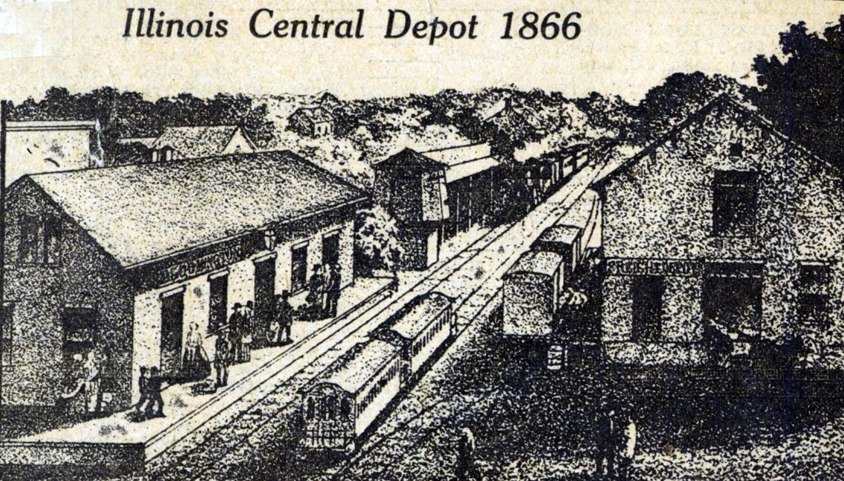
The Illinois Central Railroad leg from Ottawa to Bloomington was completed in May of 1853. The actual tracks are gone now, but the path of the old Illinois Central Railroad is still here. It’s part of Constitution Trail, a Rails to Trails project. It’s a section of the trail that runs north and south through Bloomington and Uptown Normal, under the old Camelback Bridge. The first depot was where the trail crosses Grove Street, near the Beer Nuts factory.
When it was completed, the Illinois Central Railroad had about 700 miles of track, making it the longest railroad in the country at the time! Later work on the transcontinental railroads would leave that record in the dust, but in 1856, that was notable.
The Chicago and Alton Railroad reaches Bloomington from the south
Later in 1853, a second railroad reached Bloomington, The Chicago and Alton Railroad. This railroad ran southwest to northeast through Bloomington, running from Alton, Illinois to Chicago, and would ultimately create a route from St. Louis to Chicago.
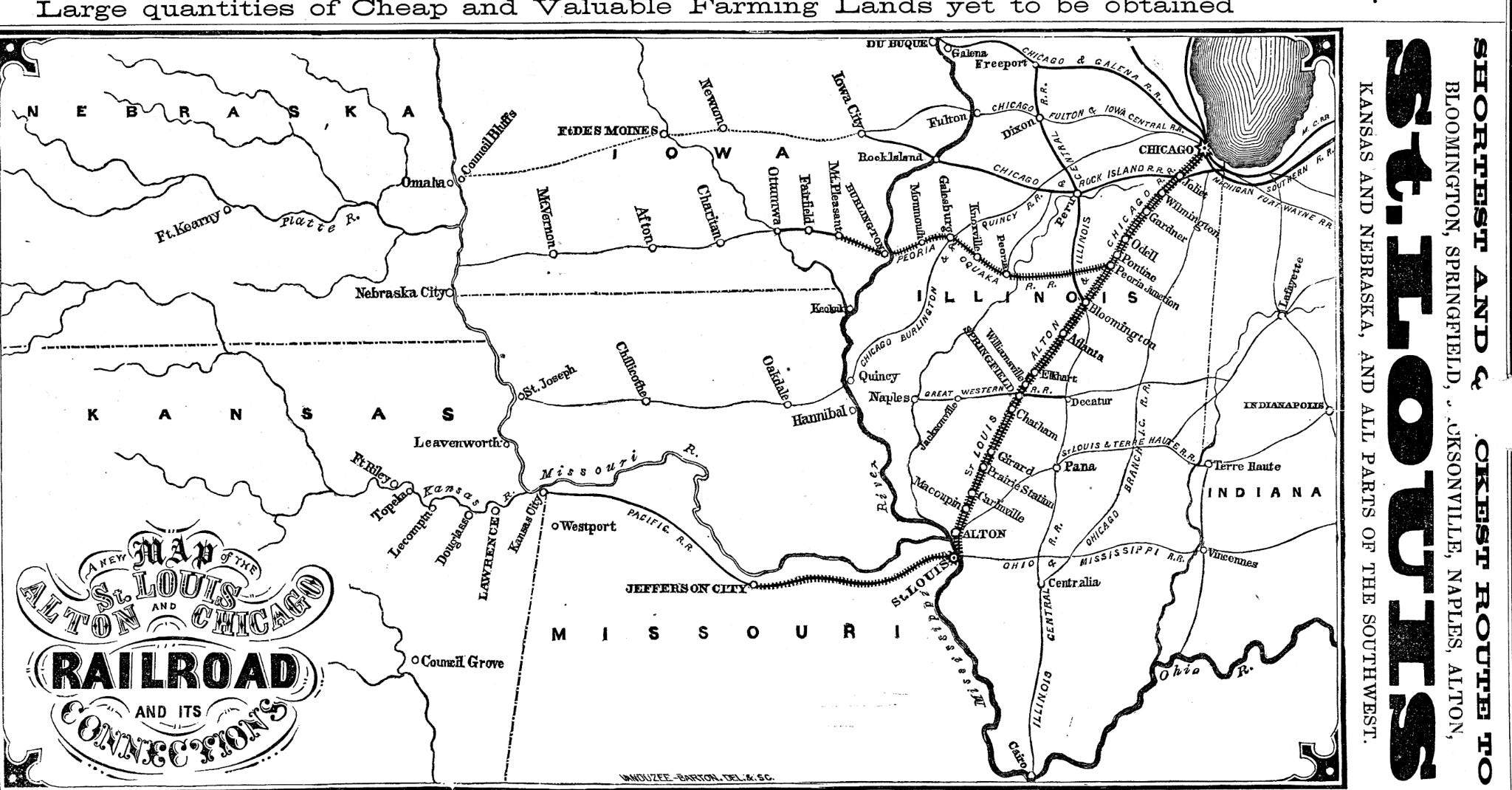
The Chicago and Alton Railroad was still under construction in 1853. The section that was complete when it reached Bloomington came from the south. You couldn’t yet ride the railroad to Chicago, since the tracks north of Bloomington weren’t built yet.
Mark Twain and President Lincoln ride the Bloomington rails
Two major railroads made Bloomington an early transportation hub. One interesting traveler on this early route was Samuel Clemons (Mark Twain)! I found a copy of a letter he wrote to his mother. He was 17 years old when he left his home in Hannibal, Missouri to strike out on his own, without telling his mother ahead of time. He sent the letter to her from New York City after he got there.
“It took a day, by steamboat and cars, to go from St. Louis to Bloomington, Ill; another day by railroad, from there to Chicago, where I laid over all day Sunday”
Mark Twain
According to his letter, Mark Twain first went to St. Louis, but couldn’t find work there. The “cars” he took to get to Bloomington would not have been automobiles, they were railroad cars. He probably rode the Chicago and Alton as far as it was built, but it hadn’t yet reached Bloomington at the time he made the trip.
According to his letter, he arrived in Bloomington, probably in August 1853. He would have boarded the Illinois Central train to LaSalle. There was a railroad from LaSalle to Chicago which he could have used to complete the trip.
In 1865, another famous passenger passed through Bloomington. President Lincoln’s funeral train ran down the Chicago and Alton line, bringing him back from Washington DC to Springfield for his burial.
More and more railroads
Many more railroads came to Bloomington over the years. Here are some of them, many of which later merged into other railroads or went out of business:
Chicago and Alton Railroad (C&A), later Gulf, Mobile & Ohio (GM&O), later Illinois Central Gulf (ICG): Arrived in October 1853.
Illinois Central Railroad (IC), later Illinois Central Gulf: Began operations in Bloomington in May 1853, later abandoned and now part of Constitution Trail.
Lake Erie & Western Railroad, later Nickel Plate Road (New York, Chicago and St. Louis Railroad): absorbed into the Nickel Plate Road in 1922.
Peoria & Eastern Railway (originally Danville, Urbana, Bloomington and Pekin Railroad): Connected Bloomington to Champaign/Urbana, later owned by Cleveland, Cincinnati, Chicago and St. Louis (Big Four), New York Central, and Conrail before portions came under the Norfolk Southern.
Lafayette, Bloomington & Mississippi Railway, later merged into Lafayette, Bloomington and Muncie Railway, later purchased by The Lake Erie and Western Railway, later sold to the Nickle Plate Railroad, later sold to Norfolk Southern: incorporated to connect Bloomington with the Indiana state line. Some tracks abandoned, some remain that are used by Rivian Motors.
Illinois Terminal Railroad (IT): An interurban electric railway and local freight service that connected Bloomington via streetcar and terminal lines until passenger operations ended in 1953 and the tracks were abandoned.
The railroads were anything but stable. One or another was constantly going bankrupt, being bought out or merged together or taken over. You’d need a very long document to keep track of all the changes over the years.
In 1873 a depot was built on the west side of Bloomington, where several railroads crossed. That depot was rebuilt in 1913, and served as the Bloomington depot until 1990. By that time rail service to Bloomington had declined significantly, and the depot was old and dilapidated. It was also located in an inconvenient part of town. A new depot was built in Normal, near Illinois State University, at what had been the junction of the Illinois Central Railroad and the Alton and Chicago Railroad. That new depot serves as the Amtrak depot today.
The Chicago and Alton Shops and the Pullman Car
Bloomington was home to a massive complex of railroad shops for the Chicago and Alton Railroad. The C & A Shops were the city’s largest employer for a span of approximately 50 years. The facility included roundhouse, locomotive repair shop, foundry, paint shop, wheel and axle shop, powerhouse, offices, and rail yards.
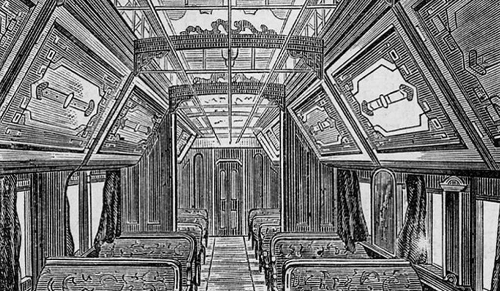
One of the things that the C & A Shops were notable for was that the first Pullman Sleeper car was built in Bloomington. Early train lines, and trips, were short, but as the railroads grew the lines were longer and it was more and more likely that a person would want or need to sleep on the train. You could, of course, sleep sitting up, but the train rocked and started and stopped. And people were walking through the car constantly, interrupting your sleep.
George Pullman tried to sleep on the train and decided there had to be a better solution. He created a special sleeping car that would allow you to lay down and provide some privacy. He built his prototypes in the Bloomington C&A Shops, with the help of a local craftsman that he trusted.
The special cars were made available for a higher rate than an ordinary seat. His first attempts didn’t do as well since few people wanted to pay extra. He finally figured out that he needed to make the cars especially nice, to be worth the extra rate. He designed a car that had beautiful detailing. The cars had extra springs to cushion the motions of the train, and doors and curtains to provide privacy. Eventually the Pullman cars proved very popular, and George Pullman created a factory in Chicago to build them.
Eventually innovations like the Pullman Cars enhanced passenger traffic on the railroads. Up to that time freight traffic was what most railroads focused their attention on. Passenger traffic was mostly a way to generate a little extra revenue.
The Junction
The Illinois Central Railroad crossed the Chicago and Alton Railroad just north of Bloomington, an area that was called The Junction. The current Uptown Normal train station is located at The Junction. That area was initially called North Bloomington.
The easy proximity to transportation to other parts of the state factored heavily into Illinois’ decision to locate the first state teacher’s college where the railroads crossed. Legislative records of the time noted that it made sense to locate the new school by The Junction for ease of transportation for students, teachers, and families.
The new school was called Illinois State Normal University. At that time, a “Normal” university was a teachers’ college. It wasn’t long before the area around it was called Normal instead of North Bloomington, and when the town was incorporated, it was incorporated as Normal, Illinois. Ironically, the school later dropped the word “Normal”, since their mission had expanded far beyond teaching, and became simply Illinois State University. That has confused people ever since about why the place is called Normal!
In early years the C&A Shops were the city’s largest employer. Later the University was. Both greatly impacted the local economy.
Bloomington’s trip from nowhere to somewhere
Bloomington is not even a place on that old 1835 map above. By 1853 it was a key location in the state, the junction of the two major railroads that crossed the state at the time. I think it’s safe to say that the railroads may have made Bloomington/Normal what it is today!
So what has happened to the railroads, and the community, since the mid-1800s?
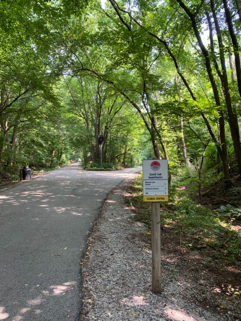
Railroads, as measured by the length of railroad track in the country, peaked around 1910. At its peak, railroads combined had 254,000 miles of railroad. Today only about half, 135,000 miles, remain in service. Bloomington’s history reflects that change as well. There were two major lines running through Bloomington. One failed and one survived. The tracks of the Illinois Central Railroad that ran north to south through Bloomington, have been abandoned. Some of that route has been picked up by a Rails to Trails path called Constitution Trail. You can walk that trail today to see where the old trains ran. The path even has one of the old train signals still standing.
The route of the old Chicago and Alton Railroad is still active. Currently the Union Pacific Railroad uses the route to transport freight, and Amtrak runs passenger service along it, from Chicago to St. Louis. Five Amtrak trains run north and five run south, daily, stopping at the Normal station.
Railroads declined partly because of the next innovation in transportation, automobiles. Eventually the explosion of automobiles led to the federally funded US Interstate Highway system. Many of the new highways followed railroad routes, since they were already developed and designed for travelers. Route 66, the Mother Road, the historic icon of the highway system, runs right along the Chicago and Alton railroad through Illinois, from Chicago to St. Louis, right through Bloomington. Bloomington’s location on the railroad ensured it would be well-connected in the automobile age as well as the railroad age.
That’s the story of just one place, and how the railroad affected it. And the corollary stories are of places that were NOT on the railroad and missed some of the benefits. Repeat those stories thousands of times and places across the country and you can start to see the revolutionary impact of railroads. Which is why railroads created some of the biggest investment booms, and busts, in history.
Resources:
Illinois Central Railroad Company. Normal, Illinois, And the Illinois Central Railroad. [Chicago, 1957.]
Railroad Historical Company. History of the Illinois Central Railway. [Chicago, 1900.]
McLean County Museum. Chicago and Alton Miscellaneous. [2006]
Wikipedia. The Alton Railroad.
Chicagology. The Chicago, Alton, and St. Louis Railroad.
The Pantagraph. Pullman Prototypes Built in Bloomington. [Bloomington, IL, June 2013]
Mark Twain Project. The Letters of Mark Twain. [New York City, 1853.]
Paul W. Gates. The Illinois Central Railroad and Its Colonization Work. [Cambridge, MA, 1934]
Unknown. A Tribute to a Depot. [2017]